Rare and Unusually Extensive Portolan Chart
By a Distinguished Family of Catalan Cartographers
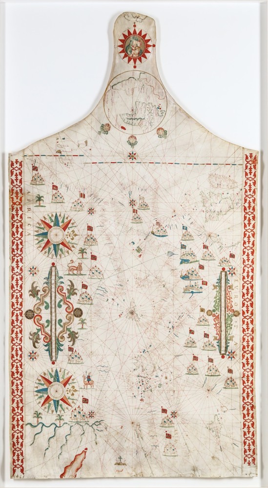
Oliva (Placido e Caloiro) A rare and unusually extensive Portolan Chart of Europe,
Western Asia and North Africa, ink, watercolour and gouache, heightened in gold, on vellum,
1090 x 585mm [c.1640]. Estimate £40,000-60,000.
One of the most extraordinary developments in maritime history emerged in the 13th century with the appearance of the Portolan chart. Its origins remain mysterious, but many cartographic historians believe these charts were born from a fusion of seafaring knowledge, academic learning and perhaps older traditions inherited from Byzantine or Arab sources.
In stark contrast to the schematic, symbolic design of medieval mappa mundi, Portolan charts revolutionised navigation by enabling sailors to plot accurate maritime routes. For the first time, coastal navigation became not just possible, but practical.
Derived from the Italian word portolano, meaning a written coastal guide, Portolan charts were informed by the direct, observational experience of sailors. Each was covered in a web of radiating lines (rhumb lines) emanating from compass roses, indicating the 32 directions of the mariner’s compass. Inland features were almost entirely omitted, focusing instead on coastlines, ports and navigational detail. Important ports were marked in red, and place names were written perpendicular to the coast for clarity.
These charts quickly became prized commodities, coinciding with a growing appetite for trade and territorial expansion. As the wealth of maritime commerce grew, so too did competition among emerging European powers. Consequently, Portolan charts became guarded state secrets in Portugal and Spain, shielded from foreign eyes with near-paranoia.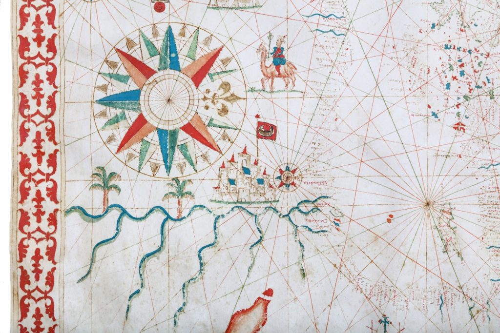
A Chart Rooted in Exploration and Elegance
Dating to the early 17th century, a rare and unusually extensive Portolan chart by Placidus Caloiro et Oliva will be offered in the upcoming sale The Warrens Library & A Fine Collection of Historical Maps & Atlases on 28 March.
The Oliva family were among the most distinguished Catalan cartographers of their day. Originally from Majorca, the family relocated to Messina, Sicily, before 1500. At least sixteen members of the Oliva family are known to have produced Portolan charts between 1538 and 1673. Messina’s strategic position, with strong links to Naples and Malta, made it an ideal base for maritime cartography.
This particular chart is centred on Sicily and the Mediterranean but extends widely across Europe, Africa and the Near East. It stretches from Ireland in the north to the Red Sea in the south and includes the Canary Islands and an inset map of the Americas at its upper edge. A roundel of the Madonna and Child sits above Sicily, adding to the chart’s devotional and decorative significance.
Function and Beauty Intertwined
Although practical in purpose, the chart is rich in artistic embellishment. Compass roses, stylised cities, heraldic flags, palm trees and exotic animals such as lions and camels add vibrancy to the piece. The inclusion of the Madonna of the Letter, the patron of Messina, is especially poignant. According to tradition, in 42 AD, the people of Messina sent emissaries to Jerusalem to honour the Virgin Mary. She gifted them a letter promising protection for their city, a symbol of faith still honoured in Sicily today.
Such decorative features were not merely ornamental. They often helped to attribute authorship, confirm provenance and attract the attention of high-ranking patrons and officials who might commission similar works.
Executed in ink, watercolour and gouache on vellum, heightened with gold, the chart compares closely to other works attributed to the Oliva family. Unlike smaller or bound versions occasionally found in atlas form, this is a particularly extensive, stand-alone example, intended to be rolled and stored as a scroll. The presence of tie-points at its edges confirms this original function.
Vellum was chosen for its superior durability and resistance to moisture, crucial for objects that might have travelled on long sea voyages or been frequently consulted.
A Unique Opportunity for Collectors
This Portolan chart is not only a remarkable document of early modern exploration but also a work of art in its own right. It bridges the realms of science, craftsmanship and history, offering a rare glimpse into the way 17th-century Europeans understood and navigated the world.
If you are interested in consigning or getting a valuation for rare maps, atlases or maritime charts, please contact our Books and Works on Paper Department at
books@chiswickauctions.co.uk
or submit an Online Valuation via our website.
Our specialists are always pleased to advise on both individual itemSave and exits and full collections.