9th Nov, 2021 10:00
Fine Books & Works on Paper


London
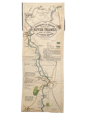
The Oarsman’s and Angler’s Map of the River Thames from its Source to London Bridge.
New edition, original text, lithographed folding panoramic map printed in colour, backed on linen. original cloth, gilt lettered to upper cover, c, 2650 x 158mm. Stanford, Publisher’s [c.1897] § Collection of c.40 folding maps of Surrey by Rowe & Teesdale, Batholomew, Cruchley, etc. various dates, v.s, (41)
Sold for £212
Includes Buyer's Premium
Do you have an item similar to the item above? If so please click the link below to submit a free online valuation request through our website.

