28th Apr, 2022 10:00
Fine Books & Works on Paper


Sprange: Tunbridge Wells
[Sprange (Jasper)]
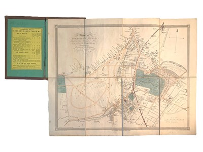
The Tunbridge Wells Guide; or an Account of the Ancient and Present State of that Place, first edition, dated 1780 on title engraved title, folding map of Tunbridge Wells, dedication and 7 plates (3 folding), with extra printed title-page dated 1785, contemporary calf, rebacked, Tunbridge Wells, J. Sprange, & London, T. Beecroft, 1780; Another copy, 8 engraved plates and folding distance table tipped-in at rear, half modern calf, 1811; [Colbran (James)] Colbran’s New Guide for Tunbridge Wells, edited by James Phippen, 14 engraved illustrations (some folding), original blind-tooled cloth binding, tear to title-page, 1840; Colbran’s Plan of Tunbridge Wells, folding map engraved by S.J. Russell, original cloth binding, inner hinge cracked, n.d.; Clifford (J., publisher) A Sketch of the Roads within 14 Miles of Tunbridge Wells Within 14 Miles, folding map laid-down on linen, contained within a contemporary slipcase with label of similar but different map, n.d. [c. 1830]; together with 13 other similar books and maps on Tunbridge Well, v.s. (18) [sold not subject to return]
Sold for £375
Includes Buyer's Premium
Do you have an item similar to the item above? If so please click the link below to submit a free online valuation request through our website.

