28th Apr, 2022 10:00
Fine Books & Works on Paper


Mediterranean Islands.- Maps
Mediterranean Islands.- Maps
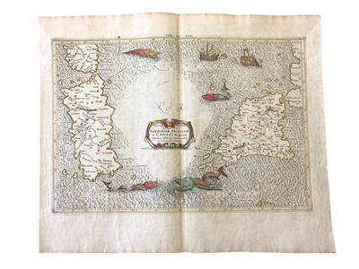
Ptolemy (Claudius) Tab. VII Europae. Complectens Sardiniam, Siciliam ac Corsicae…, engraving, later hand colouring, from the 1698 edition of Mercator’s Ptolemy Atlas: ‘Claudii Ptolemaei Tabulae Geographicae Orbis Terrarum Veteribus Cogniti’, published by Francois Halma & Willem van den Water, Utrecht & Leonard Strick, Franeker, 1698; Janssonius (Jan) Ischia Isola olim Aenaria, German text verso, inset map of Elba, Amsterdam, 1639; Homann (Johannes, heirs of) & Rizzi Zannoni (J. A., after) Li Regni di Sicilia, e Sardegna, hand-coloured, Nuremberg, 1762; v.s. (3)
Sold for £400
Includes Buyer's Premium
Do you have an item similar to the item above? If so please click the link below to submit a free online valuation request through our website.

