30th Jun, 2021 11:00
Fine Books & Works on Paper

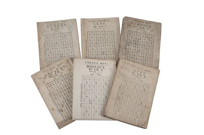


Trench Maps and Ordnance Survey Maps, 1913 - 1918
Trench Maps and Ordnance Survey Maps
collection of 13 WW1 trench maps some with contemporary annotations, a further collection of Ordnance Survey maps covering England (10), Belgium and France (2), France (10), and Northwest Europe (4), original folded canvas, printed in colour with the trenches designated in red, glossary printed on reverse, some soiling and wear to 'trench maps', dated between 1913 - 1918 (38)
Sold for £400
Includes Buyer's Premium
Do you have an item similar to the item above? If so please click the link below to submit a free online valuation request through our website.

