24th Mar, 2021 11:00
Books & Works on Paper

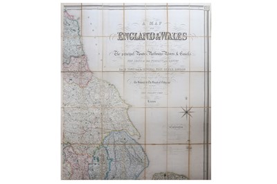


Creighton (R.).
A Map of England & WalesDivided into Counties, Parliamentary Divisions & Dioceses shewing the Principal Roads, Railways, Rivers & Canals. . . .
calligraphic title, large map in four sheets, each mounted and dissected onto linen, engraved by J. Dower showing railways and canals, original hand-coloured, folding into publisher's morocco gilt boards, upper covers detached, no spines, [total dimensions 2060 by 1700mm.,] 8vo, S. Lewis, 1839 (4)
Do you have an item similar to the item above? If so please click the link below to request a free online valuation through our website.

